Driving to Lake Tahoe from the Bay Area: Route, Timing, Chains
Updated September 30, 2026 · 10 min read
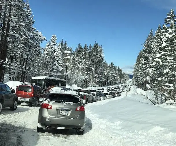
Take I-80 over Donner Summit to Truckee, then CA-89 or CA-267 to the North Shore. About four hours in light traffic, far longer on Fridays or in storms.
The short answer: from the Bay Area, take I-80 east through Sacramento and Auburn, over Donner Summit, and down to Truckee. From Truckee, CA-89 takes you to Tahoe City and the West Shore, and CA-267 takes you to Kings Beach, the lake towns on either side of it, and on to Incline Village. In light traffic the whole trip is about four hours. On a Friday afternoon it is longer, and on a storm day it can be twice as long. Don't take US-50. It goes to South Lake Tahoe, and every one of our homes is on the North and West Shore.
Most of our guests drive up from the Bay Area. On a clear Tuesday it's an easy drive. On a snowy Friday before a holiday it's a long one. Below: the route, how long it takes, what chain controls mean, and a five-minute check to run before you leave.
Where to stay at the end of the drive
Search by datesWe manage 41 homes, all on the North and West Shore, which is exactly where I-80 lets you off. By town:
- Incline Village: 20 homes
- Kings Beach: 6
- Carnelian Bay: 5
- Homewood: 3
- Tahoe City: 2
- Tahoe Vista: 2
- Tahoma: 2
- Crystal Bay: 1
One is right on the water: Lakeside Luxe Retreat in Kings Beach, our only lakefront home, at the bottom of CA-267. None of our homes are ski-in/ski-out, but plenty are a short drive from the lifts. See ski cabin rentals if skiing is the reason for the trip, or rentals for large groups if you're filling more than one car. Our homes don't take pets.
Book on our own site rather than an app. Our Airbnb prices are set 28% above the price on our own site (Vrbo 17%), and each home page shows the saving for your dates. The details are in booking direct vs Airbnb.
Ready to plan the drive? Search by your dates, pick the town at the end of your route, and check the home's driveway note before you pack the chains.
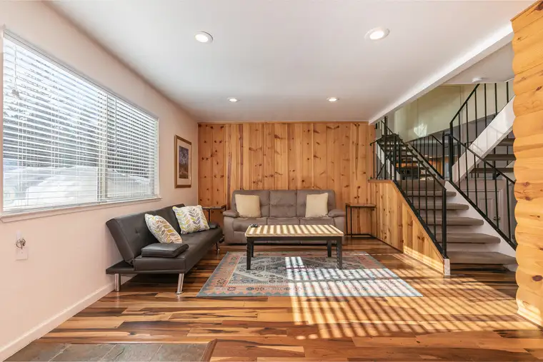
Trailside Tahoe Townhouse
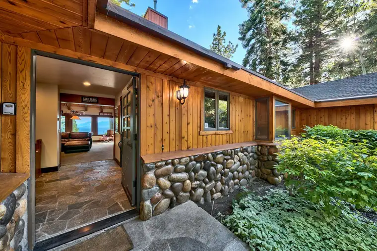
Mammoth Haven Retreat
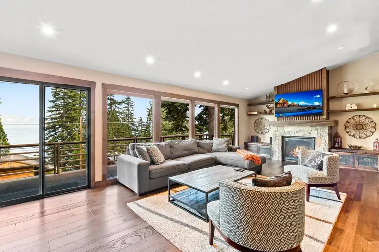
Tranquil Tahoe Haven
Book direct and pay less than for the same home on Airbnb: pick dates on any home to see the difference.
Thinking of buying in Tahoe City? See Tahoe City homes for sale on Real Estate Tahoe, our sister brokerage.
The route at a glance
| Leg | Road | What to expect |
|---|---|---|
| Bay Bridge to Sacramento | I-80 east | City and valley traffic. This is where a late Friday start loses most of its time. |
| Sacramento to Auburn | I-80 east | The climb into the foothills starts here. |
| Auburn to Donner Summit | I-80 east | Mountain freeway up to 7,240 feet. In storms, chain controls usually go up on this stretch and the next. |
| Donner Summit to Truckee | I-80 east | The descent to Truckee, where you leave I-80. |
| Truckee to your town | CA-89 or CA-267 | The last stretch to the lake. See the town table below. |
San Francisco to the North Shore is roughly 200 to 220 miles, according to Shaka Guide, and California Crossings puts San Francisco to Tahoe City at 199 miles. Where you start in the Bay Area and which town you're headed to change the number, so check your map app for your own door.
Why I-80 and not Highway 50
Two highways cross the Sierra to Lake Tahoe from the Bay Area. US-50 goes over Echo Summit to South Lake Tahoe. I-80 goes over Donner Summit to Truckee, just north of the lake. Every home we manage is in a North or West Shore town, so for our guests US-50 goes the wrong way. You'd reach the lake at its south end and then have to drive most of its length to get to us.
The roads are built differently, too. California Crossings describes Donner Summit on I-80 as a four-lane freeway, while Echo Summit on US-50 is one lane in each direction. When a storm slows everyone down, the extra lanes make a difference.
Donner Summit is 7,240 feet. Nobody should be surprised by snow at that elevation between November and March, and Tahoe.com notes that snow is possible anywhere in that window.
The last miles: Truckee to your town
You leave I-80 at Truckee. After that, which road you take depends on the town. Here's where our homes are and how to get to each one:
| Town | Our homes | From Truckee |
|---|---|---|
| Tahoe City | 2 | CA-89 south along the Truckee River to the lake. |
| Homewood | 3 | CA-89 to Tahoe City, then continue south on CA-89 along the West Shore. |
| Tahoma | 2 | Same as Homewood, a little farther south on CA-89. |
| Carnelian Bay | 5 | CA-267 to Kings Beach, then west on CA-28. Or CA-89 to Tahoe City, then east on CA-28. |
| Tahoe Vista | 2 | CA-267 to Kings Beach, then a short way west on CA-28. |
| Kings Beach | 6 | CA-267 all the way. It ends at the lake in Kings Beach. |
| Crystal Bay | 1 | CA-267 to Kings Beach, then east on CA-28, which becomes NV-28 at the state line. |
| Incline Village | 20 | CA-267 to Kings Beach, then east on NV-28 through Crystal Bay. |
CA-267 runs 12.69 miles from Truckee to Kings Beach, past Northstar. CA-89 follows the Truckee River down to Tahoe City and then runs along the West Shore. Once you reach the lake, CA-28 and NV-28 follow the North Shore between Tahoe City and Incline Village.
Pick your exit before you pick your house. If you're driving from the Bay Area and want the shortest last leg, Kings Beach and Tahoe City sit right where CA-267 and CA-89 meet the lake. Incline Village has the most homes we manage (20), a few minutes farther along the shore. Browse by town: Tahoe City, Kings Beach, Carnelian Bay, Homewood, or see every North Lake Tahoe town at once.
How long it really takes
The honest answer is that it depends on the day of the week, the time you leave, and the weather. Here's what the published estimates say:
| Situation | Typical time, San Francisco to the North Shore | Source |
|---|---|---|
| Light traffic, clear roads | About 3.5 to 4.5 hours (about 4 hr 15 min to Tahoe City) | Shaka Guide, California Crossings |
| Friday afternoon departure | Add an hour or more | California Crossings |
| Winter storm with chain controls | 8 hours or more | California Crossings |
| I-80 construction in 2026 | Up to two hours of cumulative delay | Caltrans District 3 |
Friday out, Sunday back
On weekends the traffic goes one way on Friday and the other way on Sunday. Friday afternoon, the Bay Area and Sacramento head for the mountains, and California Crossings says a Friday afternoon start adds an hour or more. Sunday westbound traffic back toward the Bay is heavy too. If you can, arrive on a weekday or leave a day later than everyone else.
Departure windows
The one window to avoid is clear: Tahoe.com advises not leaving between 4 and 7 p.m., when commute and weekend traffic pile on top of each other. So, practically:
- Friday: leave in the morning or around midday, or wait until the evening rush has passed. If you can work remotely, working from the house on Friday beats working from the car.
- Sunday: plan for heavy traffic heading west. An early start, or staying for dinner and driving later, are the usual ways around it.
- Holiday weekends: everything above, only worse. Consider coming up a day early.
- Storm days: the forecast matters more than the clock. If a storm is due on your arrival day, driving up ahead of it is usually easier than driving through it.
For the time of year, see the best time to visit Lake Tahoe.
2026 construction on I-80
On August 21, 2026, Caltrans announced construction on I-80 in the Sierra with cumulative delays of up to two hours, at work zones that include Blue Canyon, Alta, Monte Vista and Soda Springs. Caltrans' own advice is to check before you go. Work zones and schedules change through the season, so read the current Caltrans notice and QuickMap on the day you drive rather than relying on this page.
Chain controls, explained
In winter storms, Caltrans sets chain controls on mountain highways. They have three levels, and what you must do depends on the level and your vehicle. These definitions are quoted from Caltrans' chain control page.
| Level | Caltrans' wording | What it means for you |
|---|---|---|
| R-1 | "Chains are required on all vehicles except passenger vehicles and light-duty trucks under 6,000 pounds gross weight and equipped with snow tires on at least two drive wheels." | With snow tires on your drive wheels, an ordinary car can keep going without chains on. Without snow tires, chain up. |
| R-2 | Chains are required on all vehicles "except four-wheel/all-wheel drive vehicles with snow-tread tires on all four wheels." | A 4WD or AWD vehicle with snow-tread tires on all four wheels can continue without chains on. Everyone else chains up. |
| R-3 | Chains are required on "all vehicles, no exceptions." | Everyone chains up, 4WD included. |
Do I need chains if I have 4WD?
You need to have them with you. Caltrans requires vehicles on snow tires to carry chains in a chain control area, and 4WD and AWD vehicles to carry traction devices, per its chain control and chain requirement pages. Under R-2 you may not have to put them on, but under R-3 everyone does, and the level can change while you're on the road. Practice fitting your chains in your driveway at home, not on the shoulder of I-80 in the dark.
Speed limit
Caltrans sets chain control speed limits of 25 or 30 mph. On I-80 the limit is 30 mph, per Caltrans District 3. That limit is a big part of why a storm day takes so long.
Where controls usually go up on I-80
In storms, controls commonly run eastbound from Kingvale to Truckee and westbound from the Donner Lake Interchange to 4.7 miles west of Kingvale, as the Sierra Sun reported in December 2020. That is a typical pattern, not a fixed rule. Caltrans moves the limits with the storm, so check QuickMap for where they are today.
Signs warn of the control about a mile before the checkpoint, according to Caltrans. That mile is where you pull off and chain up if you need to. At the checkpoint, the CHP can cite drivers who aren't in compliance, and Caltrans can turn vehicles back.
Chain installers
In chain control areas you'll see people offering to fit chains for you. Caltrans says they are independent businesses, not Caltrans employees, and they are not allowed to sell or rent chains. So bring your own set. If you hire an installer, get a receipt and note their badge number.
Taking chains off
Remove chains once you pass the "End of Chain Control" sign, in a safe spot off the traffic lanes.
Winter on CA-89, CA-267 and NV-28
I-80 gets the headlines, but the roads from Truckee down to the lake get chain controls in storms too. The Sierra Sun's winter reporting gives SR-267, SR-89 and SR-28 as examples of routes that get controls. That isn't a standing rule, but it means making it over Donner Summit doesn't finish the job.
- CA-89 (Tahoe City, Homewood, Tahoma): follows the Truckee River to Tahoe City, then the West Shore. Check QuickMap for controls on 89 separately from I-80.
- CA-267 (Kings Beach, Tahoe Vista, Carnelian Bay, Crystal Bay, Incline): climbs past Northstar before dropping to Kings Beach. In a storm, check it before you leave Truckee.
- NV-28 (Crystal Bay, Incline Village): once you cross the state line you're on Nevada roads. Nevada posts its chain requirements on nvroads.com, not QuickMap.
Then there's the driveway. Several of our homes have steep driveways, and each home's page says when 4WD is needed. If you're booking for a winter trip, read that note before you book, and match it against the car you're actually bringing. For more on the season, see Lake Tahoe in winter.
The five-minute check before you leave
This takes five minutes and can save you hours:
- Open QuickMap. Caltrans QuickMap (quickmap.dot.ca.gov, also available as an app) shows chain controls, road cameras and closures. Look at I-80 over Donner and whichever of CA-89 or CA-267 you're taking.
- Or call. Caltrans road information is at 1-800-427-7623.
- Headed to Crystal Bay or Incline? Check nvroads.com for Nevada conditions and chain requirements on NV-28.
- Check your tires. Caltrans District 3 recommends at least 6/32 inch of tread in snow areas.
- Pack the car. Chains or traction devices, water, blankets, snacks and a flashlight, per the same Caltrans release.
- Fill the tank before the mountains. If you end up stuck in a closure, you'll want the heat running.
- Read the construction notice for 2026 work on I-80.
Then check your home. Open your home's page and read the driveway and parking notes. If the page says 4WD, bring 4WD. See all our homes and filter by town, or go straight to cabins with a hot tub for somewhere to thaw out after the drive.
Not driving? Take the train
If the thought of I-80 in a storm is the problem, there's a train. Amtrak's California Zephyr runs daily and stops at Emeryville, Sacramento, Truckee and Reno. From Emeryville you can ride over the Sierra to Truckee and let someone else handle the pass.
At Truckee, TART buses connect at the Truckee Depot and run toward the lake towns. Check Amtrak and TART for current schedules before you plan around them. Also be honest with yourself about how much you'll want a car once you're there, since our homes are spread along the shore.
If you're coming from farther away, flying may make more sense than either. Reno-Tahoe International is the closest major airport to the North Shore. See flying into Reno for North Lake Tahoe for routes from the airport, rental cars and the North Lake Tahoe Express shuttle.
Questions
How long is the drive from San Francisco to North Lake Tahoe?
About four hours in light traffic, roughly 200 to 220 miles depending on the town. A Friday afternoon departure can add an hour or more, and a winter storm can stretch the trip past eight hours. Check your map app for your exact door.
Should I take I-80 or Highway 50 to North Lake Tahoe?
I-80. It runs over Donner Summit to Truckee, and from there CA-89 and CA-267 drop to the North and West Shore towns. US-50 goes to South Lake Tahoe, the far end of the lake from our homes, and crosses Echo Summit on one lane in each direction.
Do I need chains if I have 4WD or AWD?
You need to carry them. Caltrans requires four-wheel and all-wheel drive vehicles to carry traction devices in a chain control area, even though under R-2 they may drive without chains on if they have snow-tread tires on all four wheels. Under R-3, everyone chains up.
What is the speed limit when chain controls are up?
Caltrans sets 25 or 30 mph in chain control areas. On I-80 it is 30 mph.
What is the best time to leave San Francisco on a Friday?
Avoid leaving between 4 and 7 p.m. Leaving in the morning or midday, or after the evening rush, keeps you out of the worst of it. In 2026 also allow for I-80 construction, which Caltrans says can add up to two hours.
Can I get to North Lake Tahoe without driving?
Yes. Amtrak's California Zephyr runs daily from Emeryville through Sacramento to Truckee, and TART buses connect at the Truckee Depot. Flying into Reno is the other option.